Electromagnetic Environment Simulation Analysis and Spectrum Planning Management
The Altair spectrum software (WRAP) for electromagnetic environment simulation analysis and spectrum planning/management was originally developed by WRAP International AB in Sweden. It is designed to address a wide range of advanced planning tasks, including radio spectrum planning, radar communications, radar detection, system-level EMC for communications, aviation-grade navigation radar systems, and more. By integrating radio wave propagation and interference analysis with frequency assignment, it provides a solid foundation for the rational and efficient use of radio spectrum resources.
【 Advantages 】
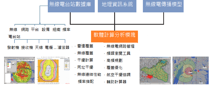
Altair WRAP is a complete spectrum management system with tightly integrated functional modules that work seamlessly with geographic processing systems. It can interoperate with existing geographic information systems and databases (station database, equipment database, antenna database, frequency database, monitoring database), and supports electromagnetic environment simulation across the full frequency band, as well as spectrum planning and management. It can be used for frequency planning and simulation of 5G wireless radio and radar communication systems.
WRAP’s dedicated database structure gives it excellent extensibility for secondary development. It provides a powerful and scalable WRAP Socket API interface for data sharing across different platforms. The WRAP Socket API hides the original software GUI and exposes an open interface at the computational engine level, allowing users to send commands to WRAP and retrieve the desired results for postprocessing and visualization. This enables direct communication and data sharing between different applications.
【 Propagation Models 】
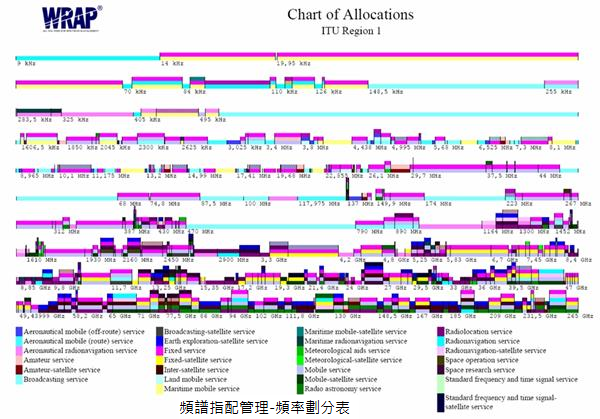
WRAP supports a wide range of full-band propagation calculation methods, including ITU-R recommendation models and empirical/statistical models, combined with station data and GIS information for radio wave propagation calculations. It supports propagation analysis in the 10 kHz to 300 GHz frequency range.
1. Integrated multi-model radio propagation capability
A. ITU-R recommendation models
B. Empirical and statistical models
C. Full-band modules ITU-R P.368 (10 kHz to 30 MHz) and P.2001-1 (30 MHz to 50 GHz)
2. Radio wave propagation calculations combined with station data and GIS information
3. Supports radio propagation calculations from 10 kHz to 300 GHz
4. Automatic model selection, with optional manual override
Generic propagation models:
-
ITU-R P.526-6 (considering detailed terrain data)
-
ITU-R P.452-9 (considering detailed terrain data)
-
ITU-R P.370-7, ITU-R P.1546-4 (considering detailed terrain data)
-
ITU-R P.169-1
-
ITU-R P.1147 (medium-wave ionospheric scatter model)
-
ITU-R P.617 (beyond line-of-sight ionospheric scatter model)
-
Free-space
-
Longley-Rice
-
Okumura model
-
COST-231-Walfish-Ikegami, SUI-WiMAX
-
ITU-R P.368 (10 kHz to 30 MHz) and P.2001-1 (30 MHz to 50 GHz) (considering detailed terrain data and multiple algorithms)
【 Software Architecture and Computational Functions 】
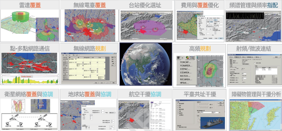
【 Typical Application Areas 】
Broadcast and TV systems: broadcast, TV broadcasting, single-frequency network planning, radio coordination
Civil aviation: station coverage, route/airway coverage evaluation, interference investigation, site selection, interference coordination, etc.
Defense: HF communication systems, VHF/UHF communication systems, radar systems, navigation systems, electronic warfare systems, microwave link systems, and more.
【 Typical Applications 】
Richin Tech is the "expert in CAE and AI data analytics", and we have completed many successful case studies.
▶ Contact us now to get more information.
▶ Subscribe to the Richin YouTube channel to explore more about CAE and data analytics.